BRRR! It Was SO Cold! 🥶
A long, long, LONG time ago, the world was super duper COLD! ❄️ Ice covered EVERYTHING! The ground, the mountains, even where your house is now!
🧊
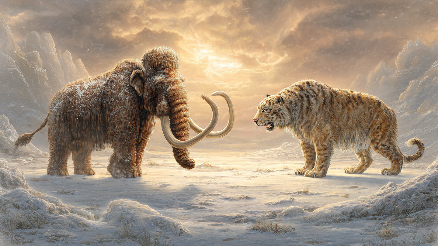
Big Fluffy Elephants!
There were animals called woolly mammoths! They looked like GIANT fluffy elephants with HUGE curvy tusks! 🦣
They had thick, shaggy fur to keep warm in the snow. Imagine an elephant wearing a big fuzzy coat!
🐅
Cats With GIANT Teeth!
There were cats called saber-toothed cats! Their teeth were SO LONG they stuck out of their mouths! 😮
Those teeth were as long as a BANANA! Can you imagine a cat with banana-sized teeth?!
🏔️
Mountains of Ice!
The ice was thicker than the TALLEST buildings! It moved sloooowly across the land, pushing rocks and dirt. It carved out valleys and made lakes!
Some of those lakes are still here TODAY! 💧
👨👩👧👦
People Lived There Too!
Early people were SO smart! They made tools from rocks 🪨 and kept warm with FIRE 🔥 and animal skins!
They painted pictures on cave walls! Some of those paintings are still there after thousands and thousands of years!
Then It Got Warm!
Slowly, slowly, the Earth got warmer. ☀️ The ice melted. The big animals went away. But the land they shaped is still here!
Can you feel how warm it is today? That is because the ice went away! 🌈
When Earth Was Frozen 🧊
Thousands and thousands of years ago, the Earth was much colder than it is now. Huge sheets of ice called glaciers covered a lot of the land. It was like a giant freezer!
🦣 Amazing Ice Age Animals
Woolly mammoths were like elephants but covered in thick brown fur. They had long, curved tusks and lived in the cold grasslands.
Saber-toothed cats had teeth almost 7 inches long! They were not like our cats today. They were strong hunters as big as lions.
There were also mastodons, which were cousins of the mammoths, and giant ground sloths that were taller than a grown-up!
🏔️ Glaciers Shaped the Land
Glaciers are rivers of ice that move very slowly. As they moved, they carved mountains, dug valleys, and created lakes. The Great Lakes in America were made by glaciers!
👩🦱 How People Survived
Early humans were really clever! They made sharp tools from rocks to cut food. They used fire to stay warm and cook. They wore animal skins like coats. They even built shelters from mammoth bones!
🌡️ The Ice Melted
About 11,700 years ago, the Earth started warming up. The glaciers melted and the land changed. Many big animals disappeared, but humans kept going. They started farming and building villages!
The Ice Age ❄️
The Ice Age was a time when huge glaciers covered the earth. It lasted from about 2.6 million years ago to 11,700 years ago.
Key Points
Massive ice sheets shaped mountains, valleys, and coastlines. The glaciers were sometimes over a mile thick! As they slowly moved across the land, they carved out places like Yosemite Valley and the Great Lakes.
🦣 Ice Age Animals
Animals like woolly mammoths, saber-toothed cats, and mastodons lived during the Ice Age. Woolly mammoths stood about 11 feet tall and weighed around 6 tons. Saber-toothed cats had 7-inch-long canine teeth built for taking down large prey. Mastodons were shorter than mammoths but more heavily built.
There were also giant ground sloths that weighed 4 tons, dire wolves that hunted in packs, and short-faced bears that stood 11 feet tall on their hind legs!
👤 Early Humans
Early humans survived using tools, fire, and animal skins. They made spears with stone tips, built shelters from bones and hides, and painted incredible art on cave walls. The paintings at Lascaux in France are about 17,000 years old and show horses, bulls, and deer in amazing detail.
🌡️ The End of the Ice Age
The Ice Age ended when Earth got warmer. Changes in Earth's orbit around the Sun caused temperatures to rise. Glaciers retreated, sea levels rose about 400 feet, and many large animals went extinct. Humans adapted by inventing agriculture, which changed everything.
Fun Facts!
- We actually found frozen woolly mammoths in Siberia with fur and muscles still preserved!
- During the Ice Age, you could walk from Asia to North America because the sea level was so low it exposed a land bridge called Beringia.
- Scientists think Earth has had at least five major ice ages in its 4.5 billion year history.
The Pleistocene Ice Age
The Quaternary glaciation, commonly called "the Ice Age," spans from approximately 2.58 million years ago to 11,700 years ago. It was not one continuous freeze. Multiple glacial periods (cold phases) alternated with interglacial periods (warmer phases). We currently live in an interglacial period called the Holocene.
Glacial Mechanics
At the peak of the Last Glacial Maximum (LGM), about 26,500 years ago, ice sheets covered roughly 32% of Earth's land surface. The Laurentide Ice Sheet alone stretched from the Canadian Arctic to modern-day New York and was up to 2 miles thick in places. For comparison, today ice covers about 10% of land.
Glaciers sculpted landscapes through two primary processes: erosion (plucking rocks and grinding bedrock) and deposition (dropping sediment as they retreat). U-shaped valleys, moraines, drumlins, and erratic boulders are all glacial signatures you can still identify today.
Megafauna
The Pleistocene hosted an extraordinary diversity of large animals:
- Woolly mammoth (Mammuthus primigenius) - 11 ft tall, 6+ tons, adapted with small ears, thick fat layer, and 3-foot-long fur
- Saber-toothed cat (Smilodon fatalis) - 620 lbs, 7-inch canines with serrated edges. Likely an ambush predator, not a pursuit hunter
- American mastodon (Mammut americanum) - forest browser (not grazer like mammoths), identified by its cone-shaped tooth cusps
- Giant ground sloth (Megatherium) - 13 ft tall standing upright, 4+ tons. South American origin, migrated north via the Isthmus of Panama
- Dire wolf (Aenocyon dirus) - recent DNA analysis reclassified it as a distinct genus, not closely related to modern gray wolves despite similar appearance
Human Adaptation
Multiple human species overlapped with the Ice Age. Homo erectus, Neanderthals, Denisovans, and Homo sapiens all developed strategies for surviving glacial climates. Key innovations included:
- Controlled fire use (evidence from 400,000+ years ago)
- Sewn clothing using bone needles (about 40,000 years ago)
- Cave art at Lascaux (~17,000 BP), Chauvet (~36,000 BP), and Altamira (~15,000 BP)
- The Beringia land bridge migration into the Americas (~16,000-13,000 BP)
The Extinction Debate
Why did most megafauna disappear around 11,700 years ago? Scientists debate two main hypotheses: climate change (warming eliminated cold-adapted habitats) vs. human overkill (expanding human populations hunted large animals to extinction). The most likely answer involves both factors working together, with timing varying by continent.
Quaternary Glaciation: Cycles, Climate, and Collapse
The Quaternary glaciation represents Earth's most recent series of glacial events, beginning approximately 2.58 Ma (million years ago) at the Gelasian stage. The period encompasses dozens of glacial-interglacial cycles, driven primarily by Milankovitch cycles: periodic variations in Earth's orbital eccentricity (~100,000-year cycle), axial obliquity (~41,000-year cycle), and precession (~23,000-year cycle).
Ice Sheet Dynamics
During the Last Glacial Maximum (LGM, ~26.5 ka BP), global ice volume reached approximately 52 x 106 km3, equivalent to a sea level drop of ~130 meters. The four major ice sheets were:
- Laurentide (North America) - up to 3.5 km thick, volume ~34 x 106 km3
- Fennoscandian (Northern Europe) - centered on the Gulf of Bothnia, ~3 km maximum thickness
- Antarctic - larger than present by ~10-15% during LGM
- Cordilleran (Pacific Northwest) - merged with the Laurentide along the Rocky Mountain front
Ice sheet behavior is governed by the accumulation-ablation balance: snowfall in upper zones compacts into glacial ice, while melting and calving at margins determine advance or retreat. Positive feedback loops amplify changes: ice-albedo feedback (more ice reflects more sunlight, cooling further) and CO2 sequestration in ocean sediments during glacial periods.
Paleoclimatology Evidence
How do we know all this? Multiple independent proxy records converge:
- Ice cores (Vostok, EPICA Dome C) - trapped air bubbles preserve atmospheric CO2 concentrations and delta-18O temperature proxies going back 800,000 years
- Marine sediment cores - foraminiferal delta-18O records provide continuous global ice volume estimates
- Loess deposits - wind-blown silt layers correlate with arid glacial conditions
- Speleothems (cave formations) - U-Th dating provides precise chronologies of regional climate shifts
Megafaunal Extinction: The Overkill Hypothesis
Paul Martin's "blitzkrieg" model (1967) argued that naive megafauna, never having encountered human hunters, were rapidly exterminated continent by continent as Homo sapiens expanded. The chronological pattern is suggestive: Australia's megafauna disappeared ~46 ka (shortly after human arrival ~50 ka), the Americas lost 35 genera within 2,000 years of Clovis culture expansion (~13 ka), while Africa and South Asia, where fauna co-evolved with hominins, retained more large species.
However, the synergistic model now dominates: climate-driven habitat fragmentation reduced populations below viable thresholds, and human hunting delivered the final blow. Todd Surovell's work on kill-site distributions and David Meltzer's critiques of the overkill chronology have refined this picture considerably.
Glacial Legacy in the Modern Landscape
The fingerprints of glaciation surround us: the Great Lakes (glacially carved basins), Cape Cod (a terminal moraine), the fertile soils of the American Midwest (loess deposited by glacial winds), Yosemite Valley (U-shaped glacial trough), the fjords of Norway and Chile (drowned glacial valleys). Understanding glacial geomorphology is essential for modern hydrology, agriculture, and infrastructure engineering.
The Quaternary: 2.58 Million Years of Climate Oscillation
The Quaternary Period's glacial-interglacial cyclicity represents one of Earth's most thoroughly studied paleoclimate archives, offering direct relevance to contemporary climate modeling. The transition from 41-kyr obliquity-dominated cycles to 100-kyr eccentricity-dominated cycles (the "Mid-Pleistocene Transition," ~1.2-0.7 Ma) remains an active research problem. Eccentricity forcing alone is too weak to drive the observed glacial amplitude, suggesting nonlinear internal feedbacks involving ice sheet dynamics, CO2 drawdown, and Antarctic Bottom Water formation.
Ice Core Records and the CO2-Temperature Coupling
The EPICA Dome C core (Jouzel et al., 2007) provides an 800,000-year atmospheric record with CO2 concentrations oscillating between ~180 ppm (glacial) and ~280 ppm (interglacial). The tight coupling between CO2 and Antarctic temperature (delta-T ~8-10 degrees C between glacial-interglacial) has been central to climate sensitivity debates. Shakun et al. (2012) demonstrated that CO2 rise slightly led global temperature increase during the last deglaciation, consistent with CO2 as an amplifying feedback rather than merely a lagging indicator.
Current atmospheric CO2 exceeds 425 ppm, a level not seen since the Pliocene (~3 Ma), when sea levels were 15-25 meters higher and global temperatures were 2-3 degrees C above pre-industrial. This comparison provides empirical constraints on equilibrium climate sensitivity, though the transient response may differ significantly from equilibrium.
Megafaunal Collapse: A Quantitative Analysis
The late Quaternary extinction event eliminated approximately 65% of megafaunal genera (body mass greater than 44 kg) globally. The chronology is informative:
- Australia: ~88% of megafauna lost by ~46 ka; human arrival ~50-65 ka (Clarkson et al., 2017). Climate was relatively stable during this window, strengthening the anthropogenic signal.
- Americas: ~80% lost between 13-11 ka; overlap with both Younger Dryas cooling and Clovis expansion. Gill et al. (2009) used Sporormiella fungal spore decline in sediment cores to date functional megafaunal extinction to ~14.8 ka in the northeastern U.S., preceding the Younger Dryas and overlapping initial human colonization.
- Eurasia: ~36% lost, more gradual, consistent with co-evolution with hominins over ~1 Myr.
- Africa: ~18% lost, the lowest rate, reflecting the longest hominin-megafauna coexistence.
Smith et al. (2018, Science) showed that mean terrestrial mammal body mass has declined monotonically with Homo range expansion, from 98 kg (Pleistocene Africa) to a projected 4.9 kg if current trajectories continue through all extant megafauna.
Glacial Isostatic Adjustment
Post-glacial rebound (GIA) continues today: Scandinavia rises ~10 mm/yr, Hudson Bay ~12 mm/yr, while peripheral regions (U.S. East Coast) subside. GIA modeling (e.g., the ICE-6G_C VM5a model, Peltier et al., 2015) is essential for correcting satellite-based sea level measurements (GRACE, GRACE-FO) and separating ice mass loss signals from solid Earth deformation. Without GIA correction, Antarctic ice loss estimates can be biased by factors of 2-3.
The Younger Dryas: An Abrupt Climate Warning
The Younger Dryas cold reversal (~12.9-11.7 ka) interrupted the post-LGM warming with a temperature drop of ~5-10 degrees C in the North Atlantic region within decades. The leading hypothesis involves a massive freshwater pulse (possibly from glacial Lake Agassiz drainage) disrupting the Atlantic Meridional Overturning Circulation (AMOC). This event is frequently cited in discussions of potential AMOC weakening under anthropogenic warming, though the modern boundary conditions differ substantially. Recent CESM2 simulations (Ditlevsen and Ditlevsen, 2023) estimate AMOC collapse probability under high-emission scenarios, highlighting how Quaternary paleoclimate provides empirical constraints for 21st-century projections.
Why This Matters Now
The Quaternary is not merely historical. Ice core CO2-temperature coupling constrains climate sensitivity. GIA models underpin sea level projections. The Younger Dryas provides an analog for abrupt AMOC disruption. Megafaunal extinction patterns illuminate present-day defaunation dynamics. Icee's original observation holds: the Ice Age shaped mountains, valleys, and coastlines. It also shaped the analytical framework through which we understand our warming present.